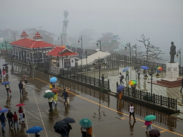
The India Meteorological Department has issued its most urgent alert in years: a severe cyclonic storm named Montha is barreling toward the Andhra Pradesh coast, with landfall expected on October 28, 2025. Winds of 90–100 km/h, gusting to 110 km/h, will slam into the shoreline between Machilipatnam and Kalingapatnam, near Kakinada. But it’s not just the wind that’s terrifying—it’s the rain. Isolated places could see over 21 cm of rainfall in 24 hours, turning streets into rivers and triggering landslides in the Eastern Ghats. Farmers, fishermen, and families across five states are bracing for the worst.
Two Systems, One Crisis
What makes this event so complex isn’t just one storm—it’s two. While Montha builds in the Bay of Bengal, a separate depression churns in the east-central Arabian Sea. The IMD’s October 21 bulletin warned of squally winds up to 55 km/h along Tamil Nadu and south Andhra coasts, with extremely heavy rainfall already soaking Tirunelveli, where Oothu recorded 14 cm in just 24 hours. That’s nearly six inches—more than Chennai’s average October rainfall—in less than a day. The dual systems are feeding off each other, creating a meteorological feedback loop that’s hard to predict.
The Landfall Timeline
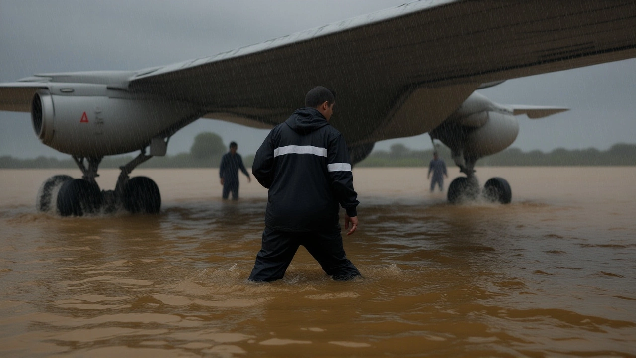
By October 25, the IMD confirmed Montha would intensify into a severe cyclonic storm by the 27th. The storm’s trajectory is still shifting, but current models show it hitting land between 4–7 a.m. on the 28th, coinciding with high tide. That’s a nightmare scenario: storm surge could push seawater 4–5 meters inland along low-lying coastal villages near Kakinada and Nellore. The Andhra Pradesh government has begun evacuating over 120,000 people from vulnerable zones. Schools, temples, and community centers have been turned into shelters.
Who’s Affected—and How
The impact isn’t confined to the coast. Telangana is on red alert for October 29, with isolated extremely heavy rainfall predicted. Rayalaseema and Yanam could see 15–20 cm of rain over three days. Even inland districts like Vidarbha and Marathawada are being warned of very heavy rainfall. Meanwhile, Odisha faces its own crisis: south coastal areas are projected to receive ≥21 cm on the 28th–29th, just as Montha weakens inland.
And it’s not just rain. Thunderstorms with lightning and 50 km/h gusts are expected over Kerala, Lakshadweep, and Gujarat. Even Bihar and Assam will see heavy downpours by October 30–31. The IMD’s October 29 bulletin reads like a checklist of disaster zones.
Fishermen, Farmers, and the Cost of Waiting
For over 200,000 fishermen along the north Tamil Nadu and Andhra coasts, the IMD’s warning wasn’t advisory—it was a lifeline. From October 25 to 28, all fishing vessels have been ordered to remain docked. Many ignored past warnings; this time, the stakes are higher. In Nellore, boat owners are tying down vessels with extra ropes and sandbags. One fisherman from Kakinada told a local reporter: “Last year, we lost three boats. This year? I’m not gambling with my children’s future.”
Farmers are watching too. The heavy rains could delay the rabi crop sowing season, which typically begins in early November. In Telangana’s cotton belt, fields are already waterlogged. “If this rain keeps coming, we won’t even get seeds in the ground,” said farmer Ramesh Reddy, standing ankle-deep in mud near Warangal. The state agriculture department has dispatched 87 mobile teams to assess damage and distribute emergency seed kits.
The Weather Blogger’s Warning
While official forecasts are precise, public anxiety is amplified by independent voices. Weather blogger Pradeep John, whose Twitter thread reached 1.2 million views by October 25, wrote: “October 27 and 28 are critical days to watch.” His analysis, based on satellite data and historical cyclone tracks, suggested that if Montha veers slightly north, Chennai could get a brutal 12–18 cm of rain in 12 hours—a scenario the IMD called “possible but less likely.”
His prediction has become a rallying cry. In Chennai, residents are stocking up on water purifiers, batteries, and dry rations. The city’s water reservoirs are already at 82% capacity. “We’re not scared of rain,” said a schoolteacher in T. Nagar. “We’re scared of what happens when the power goes out and the drains back up.”

What Comes After
Once Montha dissipates over central India, the IMD predicts a brief dry spell in Tamil Nadu during the first week of November. That’s cold comfort. The next low-pressure system is already forming in the Bay of Bengal—expected to emerge by November 7. Climate scientists warn this pattern is becoming the new normal. Between 2018 and 2025, the Bay of Bengal has produced 11 severe cyclones—nearly double the average from 1990–2000.
“We’re not just dealing with weather,” said Dr. Anjali Sharma, a climate resilience expert at the Indian Institute of Science. “We’re dealing with systems that are failing—infrastructure, early warning networks, emergency response. Cyclone Phailin in 2013 killed 45 people. This one? We’re lucky if it’s under 200.”
What’s Next
By October 31, the IMD will release its post-cyclone damage assessment. The National Disaster Response Force has pre-positioned 140 teams across five states. Helicopters are on standby. But the real test comes after the rain stops: how fast can roads be cleared? How many homes are uninhabitable? And who pays for rebuilding when insurance covers less than 12% of coastal households?
One thing’s certain: Montha won’t be the last.
Frequently Asked Questions
How severe is the rainfall expected in Andhra Pradesh and Telangana?
The IMD predicts extremely heavy rainfall (≥21 cm) at isolated locations in Telangana on October 29, with very heavy rainfall (12–20 cm) likely across Coastal Andhra Pradesh, Yanam, and Rayalaseema between October 27–29. Some areas may see more than 30 cm over 48 hours, overwhelming drainage systems and triggering flash floods in low-lying towns like Kakinada and Kadapa.
Why are fishermen being told not to go to sea from October 25–28?
Sea conditions are forecast to be rough to very rough along the north Tamil Nadu and Andhra coasts, with wave heights reaching 4–6 meters. Wind gusts over 100 km/h can capsize small boats within minutes. Since 2020, over 70 fishermen have died in the Bay of Bengal during similar warnings—making this a life-or-death directive, not a suggestion.
Could Chennai be hit harder than expected?
While the cyclone’s core will hit Andhra, a slight northward shift could bring Chennai 12–18 cm of rain in 12–18 hours—similar to the 2015 floods. The IMD considers this a low-probability scenario, but weather blogger Pradeep John and independent models suggest a 30% chance. With the city’s drainage still recovering from 2023’s floods, even moderate rain could paralyze transport.
What’s the connection between this cyclone and climate change?
Sea surface temperatures in the Bay of Bengal are now 1.5–2°C above average—warm enough to fuel rapid intensification. Since 2018, 7 of the 11 severe cyclones in the region have formed in October–November, a shift from historical patterns. Scientists link this to warming oceans and weaker wind shear, making storms like Montha more frequent and more violent.
How is the government preparing for the aftermath?
The National Disaster Response Force has deployed 140 teams with boats, drones, and medical units across Andhra, Telangana, Odisha, Tamil Nadu, and Karnataka. The Indian Air Force is holding 12 helicopters on standby. Food, water, and medicines are being stockpiled in 450 relief centers. But experts warn that last-mile delivery remains a challenge—especially in remote coastal villages with damaged roads.
When will the next storm arrive after Montha?
The IMD has already flagged a new low-pressure system forming in the Bay of Bengal by November 7. This isn’t unusual—October–November is peak cyclone season. But the frequency is. Between 2018 and 2025, 11 severe cyclones formed in the Bay, compared to just 5 between 2000 and 2010. Residents are being told to prepare for another round, even as they recover from this one.