What the IMD forecast says
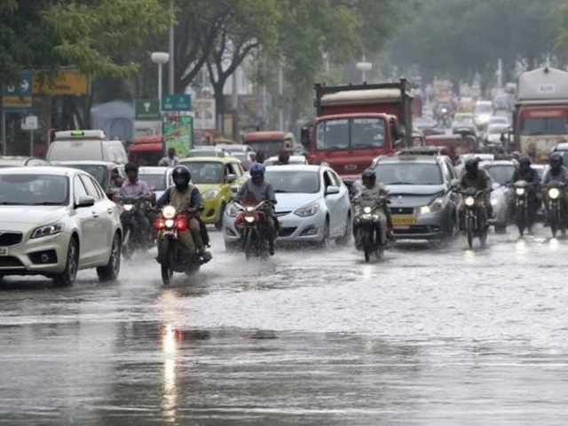
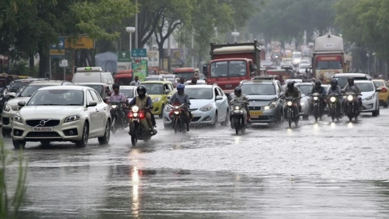
A cooler, wetter Monday is on the cards for the National Capital Region. The India Meteorological Department (IMD) expects generally cloudy skies and one or two spells of rain and thundershowers at many places in Delhi and surrounding cities, with isolated moderate showers possible during the afternoon and evening. After a day of milder conditions, the setup favors short, intense bursts that can drop a lot of water in a short time, especially in built-up areas.
In the past 24 hours, the weather shifted noticeably. Minimum temperatures slipped by up to 1°C and maximums fell by 2–3°C. Across Delhi, highs sat between 30–32°C and lows between 22–25°C—both below normal for late monsoon: maximum by 2–5°C, minimum by 1–3°C. For September 1, the IMD pegs the daytime peak at 28–30°C, which will feel cooler but more humid.
Winds have been coming in from the east and southeast and are likely to hold from the southeast through the forenoon at under 14 km/h, picking up to around 16 km/h at times. That onshore flow keeps the moisture pipeline open. Thunderclouds may build quickly in the afternoon, so lightning is a risk even where rainfall turns out brief.
The IMD has asked districts to act on orange and red color warnings issued for vulnerable pockets. These color codes are simple: yellow means “be aware,” orange means “be prepared,” and red means “take action.” Orange or red flags do not cover every neighborhood at once; they are used where the chance of heavy rain and impacts is higher—often dense urban zones, low-lying stretches, and hilly terrain.
The broader north Indian plains are under the same monsoon influence. UP and Bihar are set for cloudy skies with scattered rain and thunderstorms, with heavier cells likely in the afternoon or evening. This pattern is typical when the monsoon trough meanders over or north of the region and moisture feeds in from the Bay of Bengal.
What this means for Delhi-NCR, UP, and Bihar
For Delhi and its adjoining cities—Gurugram, Noida, Ghaziabad, and Faridabad—the main concern is quick waterlogging during the stronger spells. Underpasses and low-lying road stretches that often flood during the monsoon can fill up rapidly. If you commute through busy choke points like ITO, the Ring Road stretches near the Yamuna, or underpasses in Gurugram’s business districts, plan buffer time. Metro services usually run, but last-mile travel can slow down in heavy rain.
Urban infrastructure reacts fast to intense showers. Short outages or voltage dips are common when local feeders trip. Keep devices charged and move electronics off the floor if rooms are prone to seepage. Basements and parking pits are especially vulnerable during brief but heavy bursts.
Road safety needs extra attention in the evening window, which is when the IMD expects more widespread activity. Wet roads, poor visibility, and sudden gusts around thunderheads raise accident risk. If you’re on a two-wheeler, avoid waterlogged lanes where hidden potholes can surprise you. If your car stalls in standing water, do not restart the engine until you’re clear of the flooded patch.
For the Yamuna floodplain inside Delhi, a single day of moderate showers usually doesn’t move the needle by itself, but rapid upstream rain can. Keep an eye on local advisories if you live near the river or in colonies known for drainage overflow. The risk rises if multiple storm cells line up through the evening.
In Uttar Pradesh, eastern districts and the Terai belt tend to pick up heavier downpours under a moist southeast flow. Low-lying neighborhoods in cities like Lucknow, Gorakhpur, and Varanasi often see quick pooling during evening storms. Western UP may stay on the lighter side early in the day and turn stormier toward late afternoon if convective clouds mature.
Bihar usually feels the Bay of Bengal feed more directly. Patna, Gaya, Bhagalpur, and towns along the Gandak and Kosi basins could get scattered to fairly widespread showers with thunderstorms. If heavier rain lines up upstream in Nepal, river levels can respond, so districts near the Kosi, Gandak, Bagmati, and Ghaghara should track updates from local control rooms.
The drop in temperature offers some comfort. A 28–30°C high with cloud cover takes the edge off the late-monsoon heat. Humidity will stay high, so it may feel muggy, but the heat stress is lower than last week’s sunny spells. On the upside, a few showers often scrub the air; PM2.5 levels typically improve for a time after a rain event, especially when winds are from the southeast.
Farmers get mixed news. Rain helps paddy and keeps soil moisture healthy for late-season intercultural operations. But intense, short bursts can lodge tender paddy or flood freshly transplanted fields. In UP’s sugarcane belts and Bihar’s maize pockets, avoid water stagnation around the root zone; quick channels to drain excess water after a heavy spell reduce disease pressure.
Lightning remains the single biggest hazard during thunderstorms. Outdoor workers, construction crews, and delivery riders are most exposed. If thunder is audible, head indoors or into a hard-topped vehicle. Avoid sheltering under lone trees or near metal structures, and wait 30 minutes after the last thunderclap before resuming outdoor work.
Here’s a quick checklist if you’re in a rainfall-prone part of Delhi-NCR, UP, or Bihar today:
- Charge phones and power banks; keep a small torch handy.
- Avoid underpasses and low-lying roads during peak rain; take known detours if needed.
- Park cars away from trees and basement ramps; don’t leave vehicles in flood-prone lots.
- Secure loose items on balconies; wind gusts around storms can knock things off.
- Store drinking water to avoid short-term supply issues if pumping stations slow.
- For homes with past seepage, move rugs, papers, and electronics off the floor.
- Farmers: clear field drains; pause pesticide sprays if rain is within 3–4 hours.
Travel plans may need a cushion. Evening flights sometimes face delays when convective clouds sit over the runway path, and brief ground halts are not unusual in thunderstorms. Trains tend to keep moving, but approach speeds slow during strong rain, so expect some late arrivals.
Color warnings, once issued, can change quickly as storms build or collapse. A yellow alert can shift to orange if a cluster intensifies over a city zone. That’s why local advisories matter more than a single morning forecast. If your area’s control room pushes a fresh message, treat it as the latest word.
For now, the most likely outcome is on-and-off showers through the day, with the more active weather in the afternoon and evening. Many places could see very light to light rain, a few could catch a moderate burst, and a small number may get a heavy spell that causes brief flooding. Stay weather-aware, especially if your routine puts you on the road right when those cells are most active.
If you need one line to remember: today brings a cooler, wetter setup for the capital and the northern plains, with scattered thunderstorms, short heavy bursts, and a few urban trouble spots likely. Keep plans flexible and watch for local alerts tied to the Delhi-NCR rain window in the late afternoon.